On the way out, we found a cute little town called Elbe and fell in love with the Hobo Inn.
We kept driving and were afforded this look of Mt. Rainier.
Sadly, our first stop to look at it didn't afford us the sight of the top, so we kept driving and found other tops of mountains to look at.
We had some lunch and then headed out to our hike. I packed my camera and decided my water was too heavy to carry...bad move!!! Bad move.
The first part of the hike wasn't bad, but then I looked ahead and saw this. (It was worse then the picture shows) It was straight up towards the end.
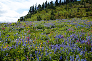
Our first section was to the top of the green part of the mountain. You can kind of see the trail in between the trees. We were afforded an amazing view.
Yes, that is a trail on the right side of the picture below. You can walk all the way to the top of the mountain.
The trail behind my head was where we were off to next. Also if you look at the mountain that looks like it has clouds sitting on top of it, that is where our hike took us in the end.
Off we went. We hiked and hiked some more. This time it was pretty much flat. Then we found this next part to stop at. If you follow where Riles is looking, you can see people and where the next stop for us would be.
I was ready to go more, but I was feeling a little tired and wishing that I had brought that dumb water. I was parched!
We kept going and were rewarded with this view. All those lighter brown lines on the green are trails.
Once we got further up, we got to see the bottom part of Mt. Rainier (dang it clouds!!! ) and the Nisqually Glacier.
This waterfall is actually apart of the picture above, you just can't really see it that far away, so I used my big lens to show it off better.
Loving the view.
The top of the moutain above me, is where most people hiked too.
We stopped here instead. I was starting to cramp up (thighs and calves) and could have made it higher, but was worried about the way down if I was already cramping there.
All together we hiked for about 3 hours. I'm still trying to figure out the elevation gain, but we started at 5,400ft and the trails we traversed were called the Paradise Meadow Trails. Once we came down we had some more food and water, then started our decent down, stopping to take photos of a waterfall.
And then right before we left the park, the top Mt. Rainier decided to show it self.
What an amazing day! I had a great time and for sure next trip we will be prepared to make it all the way to the top, or at least to the part where there is a bathroom.


No comments:
Post a Comment